Ending Mar 7, 2024 11:08 EST
Maps, Travel & Sporting Books Including The Esmond Bradley Martin Collection

69
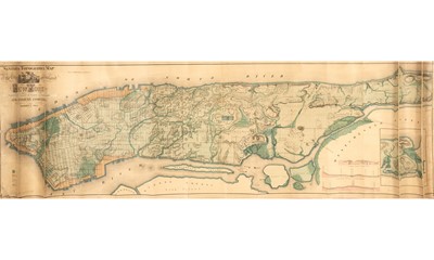
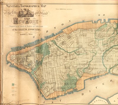
Viele's map of the underground waterways of New York City
Estate / Collection: Collection of a New York Surveyor
[MAP - NEW YORK CITY]
VIELE, EGBERT L. Sanitary & Topographical Map of the City and Island of New York. Prepared for the Council of Hygiene and Public Health of the Citizens Association. New York: Egbert L. Viele, 1865. This state with the printed paper slip pasted down to the title correcting an error, originally issued accompanying the "Report of the Council of Hygiene and Public Health of the Citizen's Association of New York upon the Sanitary Condition of the City," New York: D. Appleton & Co., 1865 (per Stokes, Iconography of Manhattan Island, Vol. III, p. 778). Measures 19 1/4 x 64 1/4 inches (48.75 x 163 cm); hand-colored lithographed map on two sheets joined, linen-backed with a pink cloth border. Lightly toned, rolled with resulting vertical creases, splits to paper mostly along the four creases closest to left and right edges, wear to corners and edges resulting in some marginal chips, tears, and losses; together with: A facsimile of the same map. Inscribed in blue ink, "Presented to Prof. E. B. Lovell by David H. Ray '01, Chief Engineer of Building, N. Y. City" Printed on thin coated cloth. Creasing and light wear.
"The most enduring nineteenth-century map of Manhattan" (Manhattan in Maps). The current map is an expansion on Viele's first sanitation map of the city, which was published in 1859 and showed only the lower half of the island. In this 1865 edition, issued to accompany his Report of the Council of Hygiene and Public Health of the Citizen's Association of New York upon the Sanitary Condition of the City, Viele maps the whole island for the first time. He also issued another, apparently later, version of the map in the same year, but with a slightly altered title, Topographical Map of the City of New York Showing Original Water Courses and Made Land, which appeared folded in a thin green cloth-bound booklet titled The Topography and Hydrology of New York (see. Doyle Rare Books, Autographs and Maps auction, April 29, 2021, lot 1033), as well as a further expanded version of the map that was issued in 1874. This map clearly delineates the city's underground rivers, ponds, canals, marshland, meadows, and sewers, as well as infilled shorelines. Viele's work on underground waterways and sanitation came at a time of great concern over disease in the city, namely cholera and malaria, which he believed were caused by an excess of moisture in the ground. He proposed that all sewage and drainage should follow the island's natural waterways, and that "the original water courses should again be permitted to have their deep and free outlets to tide water" (Manhattan in Maps). Despite Viele's intentions for his map, it found both unforeseen longevity and unrelated usefulness in the decades that followed. Its accuracy in mapping the city's waterways made it an invaluable resource to the architects, engineers, and builders constructing a rapidly growing city throughout the twentieth century. For example, it was referenced during the building of the Empire State Building, Stuyvesant Town, and United Nations Plaza. This is one of the most desirable maps of New York City and is quite scarce. Stokes, Iconography of Manhattan Island, Volume III, p. 777 & pl. 155; Cohen and Augustyn. Manhattan in Maps, p. 137.
Sold for $4,160
Estimated at $2,000 - $4,000
Includes Buyer's Premium
Estate / Collection: Collection of a New York Surveyor
[MAP - NEW YORK CITY]
VIELE, EGBERT L. Sanitary & Topographical Map of the City and Island of New York. Prepared for the Council of Hygiene and Public Health of the Citizens Association. New York: Egbert L. Viele, 1865. This state with the printed paper slip pasted down to the title correcting an error, originally issued accompanying the "Report of the Council of Hygiene and Public Health of the Citizen's Association of New York upon the Sanitary Condition of the City," New York: D. Appleton & Co., 1865 (per Stokes, Iconography of Manhattan Island, Vol. III, p. 778). Measures 19 1/4 x 64 1/4 inches (48.75 x 163 cm); hand-colored lithographed map on two sheets joined, linen-backed with a pink cloth border. Lightly toned, rolled with resulting vertical creases, splits to paper mostly along the four creases closest to left and right edges, wear to corners and edges resulting in some marginal chips, tears, and losses; together with: A facsimile of the same map. Inscribed in blue ink, "Presented to Prof. E. B. Lovell by David H. Ray '01, Chief Engineer of Building, N. Y. City" Printed on thin coated cloth. Creasing and light wear.
"The most enduring nineteenth-century map of Manhattan" (Manhattan in Maps). The current map is an expansion on Viele's first sanitation map of the city, which was published in 1859 and showed only the lower half of the island. In this 1865 edition, issued to accompany his Report of the Council of Hygiene and Public Health of the Citizen's Association of New York upon the Sanitary Condition of the City, Viele maps the whole island for the first time. He also issued another, apparently later, version of the map in the same year, but with a slightly altered title, Topographical Map of the City of New York Showing Original Water Courses and Made Land, which appeared folded in a thin green cloth-bound booklet titled The Topography and Hydrology of New York (see. Doyle Rare Books, Autographs and Maps auction, April 29, 2021, lot 1033), as well as a further expanded version of the map that was issued in 1874. This map clearly delineates the city's underground rivers, ponds, canals, marshland, meadows, and sewers, as well as infilled shorelines. Viele's work on underground waterways and sanitation came at a time of great concern over disease in the city, namely cholera and malaria, which he believed were caused by an excess of moisture in the ground. He proposed that all sewage and drainage should follow the island's natural waterways, and that "the original water courses should again be permitted to have their deep and free outlets to tide water" (Manhattan in Maps). Despite Viele's intentions for his map, it found both unforeseen longevity and unrelated usefulness in the decades that followed. Its accuracy in mapping the city's waterways made it an invaluable resource to the architects, engineers, and builders constructing a rapidly growing city throughout the twentieth century. For example, it was referenced during the building of the Empire State Building, Stuyvesant Town, and United Nations Plaza. This is one of the most desirable maps of New York City and is quite scarce. Stokes, Iconography of Manhattan Island, Volume III, p. 777 & pl. 155; Cohen and Augustyn. Manhattan in Maps, p. 137.
Auction: Maps, Travel & Sporting Books Including The Esmond Bradley Martin Collection, ending Mar 7, 2024
-
Timed Auction of Maps, Travel & Sporting Books Including the Esmond Bradley Martin Collection
-
Bidding Will Open on February 22 and Close on Thursday, March 7, 2024 beginning at 10am
-
Consignments Are Currently Being Accepted for Future Auctions
NEW YORK, NY -- Doyle will hold a timed online auction of Maps, Travel & Sporting Books closing on Thursday, March 7, 2024 beginning at 10am. Explore the world through a fascinating range of offerings featuring maps, Americana, travel, sporting books, literary sets and the Esmond Bradley Martin Collection of Africana.
Esmond Bradley Martin
Esmond Bradley Martin (1941-2018) was educated as a geographer and philosopher. He and his wife Chryssee had an enduring fascination with Africa, and settled in Nairobi, Kenya, in the mid-1970s. He wrote extensively, oftentimes in conjunction with his wife, publishing works including Zanzibar. Tradition and Revolution, Hamish Hamilton, 1978; Cargoes of the east. The ports, trade, and culture of the Arabian Seas and western Indian Ocean, Elm Tree Press, 1978; and many other works on African history and conservation. In the late 1970s, he began extensive research into the illegal trade in elephant ivory and rhino horn, which included substantial stints incognito posing as a buyer of illicit wildlife products. For a while, he served as special envoy for rhino conservation for the United Nations.
For about thirty years, beginning in the mid-1960s, Esmond Bradley Martin assiduously collected books and manuscripts on Africa and its history, acquiring a phenomenal collection of letters by many of the major English explorers of the nineteenth century, as well as numerous rarities from earlier centuries. He was buying at a time when troves of such material surfaced frequently at English auctions. Doyle was privileged to offer the first selection from his collection in the November 7, 2023 auction. We are pleased to present this second offering of property from The Esmond Bradley Martin Collection.
VIEWINGS BY APPOINTMENT
Please email Books@Doyle.com
TIMED ONLINE AUCTION
Bidding in the timed online auction will open on Thursday, February 22 and close on Thursday, March 7 beginning at 10am. Lots will close sequentially, one lot per minute, with a soft close. Should any bids be placed in the final minute, bidding will remain open on that lot for three (3) additional minutes.
PAYMENT
Please note that all purchases are subject to a Buyer's Premium
Payment can be made in the following ways:
· By credit card (an additional 3.5% fee will be charged)
· By wire transfer. For instructions, please email client.accounts@Doyle.com
PICKUPS & SHIPPING
For information, please contact client.accounts@doyle.com
We Invite You to Auction!
Consignments are currently being accepted for future auctions. We invite you to contact us for a complimentary auction evaluation. Our Specialists are always available to discuss the sale of a single item or an entire collection.
For information, please contact Peter Costanzo at 212-427-4141, ext 248, or Edward Ripley-Duggan at ext. 234, or email Books@Doyle.com

